Search This Blog

How to Confuse the Visitor to Lincoln

 The wise Elders of earlier centuries of the City of Lincoln chose a unique way to name the streets of the city.

Castle Hill


Take, for instance, Castle Hill: Castle Hill is between Lincoln's castle and cathedral but try as I might I am unable to find much of an incline between those two buildings.  It's true that it stands at the top of the well-named Steep Hill and there is a slight slope from south to north, but a hill it is not.  It is often named by locals as Castle Square.
Staying on the subject of hills, what about Lindum Road, now that is a hill, unusually for Lincolnshire, quite a steep hill, 1 in 9 (or in modern terminology 11%), I believe.  Lindum Road perpetuates the lie that started when it was named New Road.

Yarborough Road is of a similar incline to Lindum Road, it would be a hill in many other cities.  Leading off Yarborough is Carline Road which is probably the second steepest hill in Lincoln.
A busy Cornhill


I nearly forgot the Cornhill, standing east of the High Street.  There may have been a hill of corn there (pre-EU) but a more accurate name would be Corn Square.
Moving to the south of the city Canwick Road heads south from Pelham Bridge (yes it is a bridge) and out into the country.  But as it leaves the city it climbs a steep hill but it is still called Canwick Road.

If we head south west from Canwick Road we come to Cross O' Cliff Hill - and it is a hill, obviously misnamed in a moment of forgetfulness.

Imagine someone on a cycling holiday, Lincolnshire is considered (wrongly) as being flat, and they would think they could get south to north through Lincoln without climbing a hill!

There are more examples of the special naming of roads in Lincoln and maybe in other parts of the country.

I think it's true to say the residents of Lincoln are more honest and call roads that give the impression of hills, hill: e.g. Lindum Hill, Yarborough Hill, etc.


Cold Harbours

 I have discovered 17 places in Lincolnshire named "Cold Harbour", many of them are names of farms, houses or just a patch of land. I have seen many suggestions for the name, the most common is 'a place where a Roman building once stood'.


Unfortunately it is not as exciting as that; if we remove the 'H' from the second word we get Arbour, which some keen gardeners build to make a pleasant shelter to sit beneath on a warm sunny day.

Historically a Cold Arbour is a clump of trees, a ruined building or a depression in the land where travellers could get some shelter from the weather.

The image below is a map showing the location (blue tag) of a cold arbour at the junction of the High Dyke and A52 near Grantham. It's interesting that the public house was called the Blue Harbour, possibly owned by the same Lord of the Manor who owned the "Blue" inns in Grantham.  See https://itsaboutlincoln.blogspot.com/2017/11/the-blue-inns-and-sign.html


Lincoln's Libraries

Prior to The Public Libraries Act of 1850 libraries were only available to subscribers, often in stationery and book shops.

The Public Libraries Act was eventually adopted by Lincoln Corporation on 21st January 1892.  The Corporation formed a Library Authority for 3 years from 9 May 1894.  To help with the costs of setting up the library  Sir Charles Seely, MP gave £1,200., The Corporation, £200 and William Crosfield, MP, £100.

The Buttermarket is the stone fronted building on the right

The City Assembly Rooms, above the Buttermarket as St Peter at Arches was converted to the library at a cost of £1,272 17s. under the supervision of the City Surveyor, Mr R A MacBrair.

Lincoln's Public Library opened on 9th May 1895 with 7,000 books and news and reading rooms with about 100 newspapers and periodicals.

By this time the Mechanics' Institute had moved from Greyfriars to Guild Court, Danesgate Terrace where they provided about 20,000 books but many of these were only available to subscribers.

Within 15 years the library had outgrown the former Assembly Rooms and a committee was formed with the aim of building a new Public Library.  Andrew Carnegie, the Scottish-American industrialist, gave the City a grant of £10,000 toward the cost of building the new library.  Sir Reginald Bloomfield was appointed to design  the new library, he also designed the Usher Gallery

The new Library, on Free School Lane, was opened on 24th February 1914.

Lincoln Central Library on Free School Lane

By the 1990s the library had again outgrown its location and it was decided to rebuild the library, retaining the Bloomfield designed front part of the building.  Melvyn Bragg officially opened the new library on 30th October 1996.

The library continues to serve the people of Lincoln and district, as a source of information for the researcher and entertainment for the reader of novels.  Whereas, years ago you would see older people in the Reading Rooms with newspapers and magazines now you will see younger people on computers updating their Facebook status.

Who knows what the future may bring?


The Inventor "Blackmailed by the Government"

41 to 55 Westgate


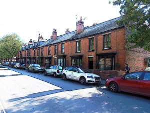
I have walked passed this row of fairly unremarkable houses many times, but today I noticed something remarkable: no UPVC!!  Each house still has its original doors and windows painted black with white frames.  Although there is some deterioration of the bricks, the houses are generally in good condition.  We all crave increased comfort and lower bills so most older houses have had windows and doors unsympathetically replaced – not these houses though.  The reason for such for this may be that the houses stand in front of Lincoln Castle and planning permission for such modernisation is not granted but I prefer to believe that the owners like to keep their houses totally original.

These are the only residential houses still standing on the south side of Westgate, number

Detail showing numbers 47 to 53

11 to 35 disappeared beneath a car park over 80 years ago.

Whilst researching these houses, I searched in the 1911 census and it seems that certain members of the population were as unhappy with the Government as many of us are now. Frank Aspland Cooper put his occupation as “Inventor blackmailed by the government”, Industry “ruination”, Employer status “sufferer”, born in Cincinnati, USA.
He published a book, “Occupation Charges” in 1887, it may be worth a read.  Mr Cooper lived at number 43, the second house from the left.  He lived there until his death in 1932 at the age of 78

The census form can be viewed here: https://search.findmypast.co.uk/record?id=GBC%2F1911%2FRG14%2F19748%2F0619&parentid=GBC%2F1911%2FRG14%2F19748%2F0619%2F1

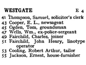
This is a list of householders of the above houses in 1913:

Previously published  

When Lincoln's Greatest Roman Treasure was Almost Lost


From the original blogpost 31 May 2012

Newport Arch was the north gate of the upper Roman town of Lindum Colonia.  It is now the only Roman arch in the country still open to traffic.  It is the entrance to Lincoln's historic centre that includes most of Roman and Medieval Lincoln.

Newport Arch probably got its name in the medieval period, many houses were demolished for the building of Lincoln castle in the late 11th century and the displaced residents moved to an area north of what is now known as Newport.  At the time it was open country but soon grew and eventually had its own market.

Built in the 3rd century, Ermine Street passed through it to link Lincoln to another major Roman provincial centre, York.  The arch was enlarged when the city became capital of the province Flavie Caesariensis in the 4th century.  The remains we see today are of the inner arch and a footway on the east side of the arch, the outer arch was demolished in the late 18th century.  The arch was much higher in Roman times, approximately 2.4 metres of it are below today’s ground level.

More about the design of the gateway was discovered in 1954 when the north-west bastion, a semi-circular  structure, was excavated, the remains of which are still visible.  There would have been another bastion on the north-east side of the gateway, the remains of that are now below the adjoining cottage.


The modern age has brought damage from motor vehicles, the worst of which happened in 1964 when a lorry carrying peas severely damaged the upper part of the arch.  This resulted in its dismantling and rebuilding.  To see an image of the accident please click here.

Lincoln’s Stonebow now stands on the site of the Roman south gate of the lower city


Over 100 more posts @  https://itsaboutlincoln.blogspot.com/p/index-to-blogposts.html

The Cross on the Hill

 The first of the twelve Eleanor Cross’s stood on Swine Green at the junction of High Street and St Catherines, not far from the present St Catherine’s Priory Centre and the foot of Cross o’ Cliff Hill.  At the top  of the hill  stood another cross, this cross marked the boundary of the southern limits of the City of Lincoln.  By 1600 this cross had been removed “by some evil-disposed person”. The Corporation ordered that a stone should be erected in its place as a landmark.

It was at this spot that the dignitaries of the  Corporation met distinguished visitors arriving from the South.  In 1445, the Mayor, the Sheriffs and aldermen, on bended knees, here received Henry VI and his young bride, Margaret of Anjou.

Mayoral Party, led by trumpeters and javelin men, leaving the Guildhall

Here 172 years later, on March 17th, 1617, the civic authorities all “in long cloth clothes of purple in grain”, the Sheriffs with white staves of office, the others carrying javelins fringed with red and white, waited to meet James I, who had been hunting along the Heath on his way from Grantham; it appears that the king took a different route and missed the civic party.

Over 100 more posts @  https://itsaboutlincoln.blogspot.com/p/index-to-blogposts.html

When Lincoln Was Numbered

19 to 23 Minster Yard are known as the Number Houses, so-called because they are thought to be the first numbered houses in Lincoln; but why start at 19?


Standing at the north-west corner of Lincoln Cathedral, which they complement.  The houses were built in the early to mid 18th century with 19th century modifications and are, as you would expect, Grade II and Grade II* listed.

Over the years many of the houses have been updated but still retain their character.  The curve of bay windows and the regularity of the Georgian windows place these houses among the finest in the city.    

When house numbering first began, under the Postage Act of 1765, buildings were often numbered in sequence, 1 to x on the left-hand side from a main road, and x+1 (opposite x) to the last number on the other side - a clockwise sequence (Lincoln's High Street retains this numbering sequence).  Later buildings on the left would usually be odd numbers and the opposite side would be even. 


At first sight, nothing remarkable about this mid-19th century row of terraced houses built for the better-off professional classes, in need of tender loving care and blighted by poorly designed double-glazed windows and the ubiquitous wheelie bin.

These seemingly two double-fronted houses are. in fact, four single-fronted houses.  The plaque to the left of the right-hand door shows number 67, and it can be seen from the wheelie bins that the houses are numbered 65 to 71.

This is the artificial stone lintel above the right-hand door:

From this lintel, it can be clearly seen that the houses were previously numbered from 43 to 46.  All the houses were unoccupied in the 1861 census, so they must have been newly built, or in the course of being built at that time.

In 1871 number 43 was still unoccupied, but the others were lived in:

  • 44 - John Heywood, age 42, a cashier at an engineering works.  Under where born: "travelling on the continent", his son, Edward, was born at Heywood, Lancashire. 
  • 45 - Elizabeth Bullivant, 65, living on her own means, born in Aisthorpe.  
  • 46 - George Williamson, 48, Manager Steam Engineer, born Gainsborough.

Sometime between 1891 and 1894, the houses were renumbered to the current sequence.

In the case of Monks Road buildings were numbered sequentially on what would be the right, and when the numbering changed number 1 was still on the right.  I believe the reason for this is that the first houses were built on the south side of the road as Monks Leys Common was on the north side.

When these four houses were built, behind them would be many of the major engineering works of the City, but in front would be a pleasant view of the countryside leading up the hill. To the left would be the recently opened cattle market with a great view of the Cathedral above it.

Many other roads, including High Street, have been re-numbered.

Monks Road Numbering 1894 - New Numbers


Monks Road Numbering 1894 - Old Numbers


Over 100 more posts @  https://itsaboutlincoln.blogspot.com/p/index-to-blogposts.html