Search This Blog

Showing posts with label Ermine Street. Show all posts

When Lincoln's Greatest Roman Treasure was Almost Lost


From the original blogpost 31 May 2012

Newport Arch was the north gate of the upper Roman town of Lindum Colonia.  It is now the only Roman arch in the country still open to traffic.  It is the entrance to Lincoln's historic centre that includes most of Roman and Medieval Lincoln.

Newport Arch probably got its name in the medieval period, many houses were demolished for the building of Lincoln castle in the late 11th century and the displaced residents moved to an area north of what is now known as Newport.  At the time it was open country but soon grew and eventually had its own market.

Built in the 3rd century, Ermine Street passed through it to link Lincoln to another major Roman provincial centre, York.  The arch was enlarged when the city became capital of the province Flavie Caesariensis in the 4th century.  The remains we see today are of the inner arch and a footway on the east side of the arch, the outer arch was demolished in the late 18th century.  The arch was much higher in Roman times, approximately 2.4 metres of it are below today’s ground level.

More about the design of the gateway was discovered in 1954 when the north-west bastion, a semi-circular  structure, was excavated, the remains of which are still visible.  There would have been another bastion on the north-east side of the gateway, the remains of that are now below the adjoining cottage.


The modern age has brought damage from motor vehicles, the worst of which happened in 1964 when a lorry carrying peas severely damaged the upper part of the arch.  This resulted in its dismantling and rebuilding.  To see an image of the accident please click here.

Lincoln’s Stonebow now stands on the site of the Roman south gate of the lower city


Over 100 more posts @  https://itsaboutlincoln.blogspot.com/p/index-to-blogposts.html

A Walk Up Steep Hill


Steep Hill is part of the north-south route that leads from Bargate in the south to Newport in the north. The route was established by the Romans almost 2,000 years ago, Ermine Street, the main route from London, would join the Fosse Way from Leicester and the south-west and leave Lincoln (Lindum Colonia) en route for Barton on Humber and York.

Steep Hill links the lower city to the older, upper city. During the later Middle Ages Steep Hill was an enclave of the Jews. Lincoln had the second larget population of Jews in England after London.

​Three of the oldest domestic buildings in Lincoln are on Steep Hill, two of them, Jews House and Jews Court are known to have belonged to Jews.

Jews House
Jews House is the last house on the Strait, but it is included here. It was built about 1170, like most houses of this age, it had a first floor hall with storage on the ground floor. The first floor window surrounds and decorative features are original although the windows are of more recent date

Originally, the ground floor would not have had windows, but ventilation holes would have been made into the walls. The chimneys on the roof are of more modern date: The house's chimney was built into the front wall over the main entrance, the arch would have had supports.

During the 12th and 13th century Jews throughout England suffered persecution: In Lincoln the Jews were blamed for the death of a Christian boy called Hugh. In 1290 Belasset of Wallingford, a Jew, lived in the house and was hanged in London for the offence of coin clipping.

The house then came into the possession of the Dean and Chapter of Lincoln Cathedral.

Most of the alterations to the House took place in the 18th and 19th centuries, the ground floor windows and additional doors were added during this time.

It is believed to be the oldest house still existing in England.

Jews Court
Jews Court stands at the southern, lower, end of Steep Hill. Built in the late 12th century and altered in the 18th, 19th and 20th centuries.
One of the upper rooms, it is thought, was used as a synagogue, but there are many factors which seem to disprove this and the general view is that the synagogue was at the rear of this building or the Jews House. At the 1290 inquest about the expulsion of the Jews it was stated that Jews Court was part of the communal Jewish property.

This area is famous for the story of "Little St Hugh", a Christian child said to have been murdered by Jews in 1255. The story was a fabrication and a plaque was placed in Lincoln Cathedral at the site of Hugh's burial​

"By the remains of the shrine of "Little St. Hugh".
Trumped up stories of "ritual murders" of Christian boys by Jewish communities were common throughout Europe during the Middle Ages and even much later. These fictions cost many innocent Jews their lives. Lincoln had its own legend and the alleged victim was buried in the Cathedral in the year 1255.
Such stories do not redound to the credit of Christendom, and so we pray:
Lord, forgive what we have been, amend what we are, and direct what we shall be"


The Jews' Court was traditionally believed to be the site of the falsified martyrdom of Little Hugh and a well in a corner of the basement was alleged to be the place where the body was concealed. In 1911, Mr Dodgson who then owned Jews Court charged visitors 3d to see the well in the basement of Jews Court, claiming it was the very well Little Hugh had been found in. Plenty of people bought a ticket, but they were duped for not only was there no connection between Jews Court and Little Hugh, but the well had only been dug in 1910 by Harry Staples of Hereward Street, Lincoln, on Mr Dodgson's instructions.

In the late 1920s Lincoln was going through a major slum clearance, Jews Court narrowly escaped demolition, due to the efforts of Lincolnshire Architectural and Archaeological Society (LAAS) who were given the building by Lincoln Corporation on condition it was refurbished.

It is now the home of the Society for Lincolnshire History and Archaeology where an excellent new and secondhand bookshop can be found.


Well Lane

Well Lane is thought to be the route Roman horse-drawn vehicles would take to reach the upper Roman town.  The tapered square case with cornice cap on the left of the image contains a mid-19th century water pump.


Soon the steepest part of the hill is reached, a handrail is provided to help with the ascent.  


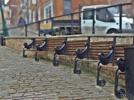
The Mayor's Chair


A Lincoln mayor from a much earlier age provided seating against the wall at the end of this section for the weary walker. A good place to sit to view the lower city, although this view is partially blocked when the tree to the left is in leaf. A new Mayor‘s Chair was installed in 2010.


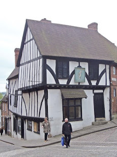
Harding House
Harding House is a 16th century half-timbered building restored in the second-half of the 20th century.  T
he home of "Aaron the Jew" was on this site in the 13th century . Aaron was a wealthy money-lender, lending money to kings as well as cathedrals and monasteries.

Today it is an art and craft gallery, run by an artists co-operative.

The Ground Floor Gallery features work by members of the co-operative, plus a wide variety of work by other artists and makers from around the country.

The Upper Gallery hosts an exhibition programme in all disciplines.


The Harlequin
the building known as "The Harlequin" is late 15th century, it was altered in the 19th century and restored in the 20th century.  It has more recent refurbishment to preserve the building for many more years.
The Harlequin inn opened in the 18th century and was renamed the Harlequin & Columbine* when it became the theatre inn; the theatre was at the far end of Wordsworth Street on Drury Lane. The Inn was closed by the city corporation in 1931 as unsuitable premises for a public house. 

It was a secondhand bookshop for over 50 years until it closed in 2017.

*Harlequin & Columbine are characters in the Mother Goose Pantomime


Bail Gate
the Bail Gate stood on the flat part of Steep Hill above the Harlequin, Click Here to Read More

Norman House


Norman House was once known as “Aaron the Jews House”, but Aaron may have lived in the Bail, above here, or in a house on the site of Harding House, a little further down Steep Hill.

It is a late 12th-century dressed stone and brick house situated on the east side of Steep Hill. It originally had shops on the ground floor and domestic rooms above. It has had a lot of rebuilding over the centuries, restored in 1878 and during the 20th century, but traces remain of the front chimney stack, ornamental string-course and doorway. The building is now home to a bag shop and a tea retailer.

The ground floor has two central entrance doorways, the left door is an 18th century insertion with an attached bow shop window and the right door is round headed with single shafts and crocket capitals under a truncated hood. To the far right is a casement shop window with a wooden pilaster surround and cornice and to the far left is a partially blocked small two light casement window.

Roman South Gate
The Roman South Gate (Porta Principalis Dextra) of the upper town stood near the top of Steep Hill.  Parts of this gate were still standing in 1788 when Gough visited the city, but the arch was demolished in the early 1700s by a householder on the east side of the gate.  According to Thomas Sympson writing in the early 18th century: (the arch was knocked down) "though not without much difficulty, as I have been informed by an eye-witness; for when the workmen, with a great deal of labour and pains, had battered one of the stones in the crown of the arch in pieces, rest being laid without mortar, sunk so equally on both sides that the hung as firm as ever, and their work was to begin anew".  The position of the gate is marked by foundation stones on the side of the road


Brown's Pie Shop


The building now known as "Brown's Pie Shop" was previously the Fox & Hounds inn. 

16th Century building re-fronted in the 18th century and a shopfront added in the 19th century.

In 1827 a horse called Bessy Bedlam won the Lincoln Gold Cup, the inn was renamed in honour of the horse. Sadly, many Lincoln people lost money having backed the horse to win the St Leger. The name reverted to the Fox and Hounds in 1849.


In 2011 Steep Hill won an award as "Britains Best Place", from the Academy of Urbanism.


Byards Leap - A Lincolnshire Legend

The legend of Bayard's Leap is locally well-known and is timeless, over the years many versions of the story have been retold; the difference is the hero of the tales, he is a knight, a soldier or a shepherd.  The story I have reproduced below the hero is a shepherd:

"On the old Roman road, called ' Ermine Street,' or ' The High Dyke,' . . . —and at a distance of some three miles from Ancaster, a Roman station . . . —and in the angle formed by the Sleaford and Newark road, which there crosses the Roman road — stands a solitary farm-house; its solitude only relieved by two cottages distant about one hundred yards, on the same side of the great highway, and, more recently erected, a small school building on its opposite side.

"Solitary in its position, its civil status also was formerly isolated, since it belongs to what was an extra-parochial farm, at the north-west corner of Rauceby, sometimes returned with the parish of Cranwell, sometimes with that of Leadenham ; but latterly (under the Act, 20 Victoria, cap. 16) constituted a separate parish in its own right.

"Close by the entrance gateway to this farm-house, on the roadside, is a block of stone, such as not uncommonly may be seen near old houses of the kind, forming two steps, from which a rider mounted his horse. This stone is inscribed with the words ' Byard's Leap.'

"Not less singular are the circumstances which are said to have given rise to the name "of ' Byard's (or ' Bayard's ') Leap,' or the Leap of the horse ' Bayard.' ... It [the Leap] is situated in the midst of what was once a lonely tract of high land, almost a waste, extending for many miles, and called Ancaster Heath. . . . The pedestrian who follows the footpath which runs along the Eastern side of the great Roman highway will observe, at a distance of some fifty yards northwards from the farmhouse of Byard's Leap, and near a pond by the roadside, four very large iron horseshoes, embedded in the soil. If he measures the distance of these shoes from the pond he will find that it is twenty paces or sixty feet, and sixty feet was the length of Byard's Leap. . . . Opposite the farm of ' Bayard's Leap ' is a plantation . . . consisting chiefly of trees of recent growth; but probably there formerly existed an older growth, whose pristine shades were more adapted to harbour weird spirits.  Within that wood, inhabiting, as it is said, a cave, but more likely a deserted quarry of the famed Ancaster stone of the district (such places of abode being still used), there lived the pest and terror of the countryside in the person of an old woman, known far and wide as, par excellence, the witch ... a dangerous character was the old beldame to anyone who ventured to thwart her or cross her path. ...
byard's leap signboard
An alternative tale
"If the old woman was denied anything which she craved, of her better-to-do neighbours they were certain speedily to suffer for it. . . . Neither man nor beast is secure from her spells. ... At length, a child having been stillborn in a cottage from which the old woman had been turned away without receiving what she asked for, the indignation ripens, and a plan is proposed, by which it is hoped that the witch's power may be put an end to, while the act shall seem to be of her own originating. The shepherd of the farm has been on something like intimate terms with the old woman, ... as is surmised . . . having had illicit dealings with her, the result, however, being that closer acquaintance with her has in no wise enkindled affection: and although afraid to ' break ' with her ... he would yet greatly rejoice ... if he could terminate the unpleasant thraldom of her influence. . . . By a sort of lottery, the shepherd is selected for the enterprise. He is to lead out the farm horses to water in the evening, at the pond by the roadside, opposite to which is the hag's den.  He is to throw a stone into the water as the horses are drinking, and whichever horse then raises its head first, he is to mount. He is to be armed with a two-edged knife.  He is to call to the old woman to come out and mount behind him. He is to stab her when she has done so as if in self-defence on her springing up behind him; it is hoped that in the struggle she will be drowned; the not unfrequent end of witches. At the appointed time he proceeds to carry out these instructions. The horses are led to the water, the stone is thrown into the pond. The first horse that raises his head on hearing the splash is the blind Bayard; a providential circumstance, since it is likely that any horse which could see would shrink from contact with the witch. 


"He mounts the horse Bayard.  He calls out to the old woman, asking her to come and ride behind him. Her reply (which has been preserved) is, ' Wait till I've buckled my shoes and suckled the cubs, and I'll be with you.' He waits, and in due time she comes forth. At his bidding, she mounts behind him.  He at once plunges his knife into her breast. The old hag, in her agony, clutches at the horse's back with the long sharp nails of her fingers. The horse in alarm makes one wild, sudden bound, which lands him full sixty feet from the spot. The witch falls back into the pond and is drowned, so her career is ended.


"Tradition says that the horse made a second bound, equal in length to the first, and which brought him to the corner of the cottages which stand further on by the side of the road ; but only the first is marked by the four huge horse-shoes, which are carefully preserved, in situ, as described above, as standing evidence and memorial of ' Bayard's Leap.' . . . It should here be stated that considerable variations from the foregoing version of the legend exist, as is usually the case with such narratives, in the form of oral tradition still floating in the neighbourhood. For instance, the personality of the hero himself varies from that of a knight-errant of the age of chivalry to that of an ordinary cavalry soldier of a more recent period. . ."

"The Legend of Byard's Leap" - Rev J Conway Walter

(Bayard is Old English meaning horse)

For many years the leap and landing points were marked by holes in the ground, these holes were probably marked parish boundaries and would be re-established at the annual "beating of the bounds".  


In the mid-19th century the then Colonel Reeve of Leadenham had three sets of horseshoes made by Bradley and Howitt of Newark.  The horseshoes were set in concrete and set in the legendary positions.
In the early 1960s the A17, a trunk road from King's Lynn to the A1, was straightened at Byard's Leap and the third set of horseshoes was in the direct route of the road.  This set of horseshoes was put into storage at Wilsford, several years later they were returned and placed near to Byard's Leap Cottages on the north side of the A17.  

Map showing the re-alignment of the A17

Reproduced with the permission of the National Library of Scotland

Lincoln's High Bridge, Unique In This Country

 
High Bridge on Lincoln’s High Street is the oldest surviving bridge with buildings on, in this country. It marks the spot where the Roman Ermine Street crossed the Witham by way of a ford, a bridge was built c2nd century.

The river was much wider than today and High Bridge was thought to be made of five arches, today only one arch remains.

There were many bridges like High Bridge in the middle ages, London Bridge for example, but all the others have long since disappeared, the only other bridges with buildings on in England are Frome Bridge dating from 1667 and Bath’s Pulteney Bridge of 1773.

At the Reformation there were as many as 52 religious buildings in Lincoln, one of them was the chapel dedicated St Thomas the Martyr which stood on the eastern side over the vaulted arch of the bridge. The chapel was paid for by Lincoln Corporation c 1200. Following the Reformation the Corporation converted the chapel into a house, it was let as a hall to the Company of Tanners and Butchers, and finally a warehouse until it was demolished in 1763. An obelisk was then erected which was also a water conduit that brought water from near the end of Monks Road. The original pipes for this were laid by the brothers of Greyfriars in the early 16th century. The obelisk was removed in 1939 due to concerns about the strength of the arch supporting it. A reconstruction of the obelisk can be seen at St Mark's Shopping Centre.

The Glory Hole,
showing medieval ribbing
The river route under the bridge was once named "The Murder Hole", bodies could be dropped in the water here without being seen and, with luck, would float downriver to Boston and onto the Wash. 

The maximum height of 9 feet and width of 22 feet together with an awkward angle under the bridge sets a limit on the size of vessels that can use the Witham from Brayford Pool to Boston, and vice versa. It now has the much happier name "The Glory Hole", this may come from the difficulty of getting large vessels through, there would be some "glory" when a boatman made it through!


Until the 1790’s the river was not navigable all year, in summer the bed of the river was often dry; there are tales of horse and coaches driven across the river in summer just west of High Bridge. Joseph Banks (1743-1820), the botanist and naturalist had commissioned the building of the Horncastle Canal, he could see that revenues on his canal would by severely restricted by the problems at High Bridge. The Corporation was reluctant to improve the navigation under the bridge because they earned porterage from the trans-shipping of cargoes. This reluctance forced Joseph Banks to look at alternative routes. William Jessop (1745-1814), the noted canal builder (locally he built the Grantham and Sleaford canals), was commissioned to investigate a likely route. Jessop put forward a scheme to route barges from Brayford Pool southwards on the upper Witham to Sincil Drain, in effect by-passing Lincoln. The Corporation realised this would be devastating for the economy of the city and, in 1795, the bed of the river beneath High Bridge was lowered at the expense of the proprietors of the Horncastle Canal. To celebrate the event boards were laid on the dry river bed and a dance took place under the bridge.

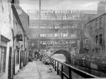
1902/3 Reconstruction
The buildings on High Bridge were renovated and put back to their original half-timbered design in 1902/3 under the direction of architect William Watkins. Jettied forward of the first-floor are carvings of King Edward VII and Queen Alexandra.


The High Bridge remains an architectural gem, Stokes coffee shop is an excellent place to enjoy a coffee. R W Stokes Co. has ground and blended coffee here for over 100 years.


Either side of the shops on High Bridge there are steep narrow steps leading towards Lincoln’s Brayford Pool, where barges and ships loaded and unloaded their cargoes. From the footpaths on the west side you can get an excellent view of the rear of the shops.


Further Reading:


The South Common, Lincoln's Southern Entrance

Lincoln Cathedral from the top of the South Common
Common Lands are a survival of the medieval age, commons were an essential part of the manorial estate, tenants of the lord of the manor would be allotted a part of the common.  Most of today's common lands are solely for grazing, but previously the land would have had many uses, ie, rights to take wood, graze pigs in the autumn, take sods for fuel.  Much of the common land of this country was lost at the enclosures, it was seen as an opportunity for landowners to claim common land for themselves.  The total common land today in this country totals no more than 4% of the total land area.

The South Common is one of three surviving common lands in Lincoln, the others are the West Common and the Cow Paddle.  The Lincoln commons are "owned by the Mayor, Aldermen and Citizens of Lincoln".  Until 150 years ago there were two other commons, Monks Leys Common, the bulk of which was sold for housing and the remainder was used for the Arboretum; Holmes Common, this was sold to The Great Northern Railway.

Any householder living south of High Bridge had a right to graze cattle on the South Common, although Freemen had rights to graze a greater number.  The area of the common is approximately 180 acres, although may have been reduced because of the recent modifications on the hill section of Canwick Road.

The Promenade
In 1843 iron fencing was used to surround the South Common and at about the same time a new pathway was established which ran across the crest of the hill and was called the "Promenade", the picture to the right is a postcard that was posted in July 1909

At a location near the top of the common stood a cross, it was here that the mayor, sheriff and other civic dignitaries would greet important visitors to the City.  By 1600 the cross had been removed by "some evil disposed person", the corporation ordered that a stone be placed at the spot as a marker, this too has been lost.

At the south east corner of the South Common once stood the city gallows.

The first Roman legion is believed to have erected a fort on the South Common, it would have been a wooden palisade structure.  Ermine Street crossed the A15 just below Cross O' Cliff Close, running down the common, crossing South Park west of Queen's Park.  Ermine Street divided at the top of the common, a direct route so that troops could be moved quickly to any troublespot, and an easier route for carts, etc.


First published 17th May 2015