by itsaboutlincolnHigh Street passes over the original Norman stone bridge, erected about 1160, possibly replacing one made of wood.

High Bridge on Lincoln’s High Street is the oldest surviving bridge with buildings on it in this country. It marks the spot where the Roman Ermine Street crossed the Witham by way of a ford; a bridge was built c. 2nd century.
The river was much wider than today, and High Bridge was thought to be made of five arches; today, only one arch remains.
There were many bridges like High Bridge in the Middle Ages—London Bridge, for example—but all the others have long since disappeared. The only other bridges with buildings on them in England are Frome Bridge, dating from 1667, and Bath’s Pulteney Bridge of 1773.

At the time of the Reformation, there were as many as 52 religious buildings in Lincoln. One of these was a chapel dedicated to St Thomas the Martyr, which stood on the eastern side of the bridge over its vaulted arch. The chapel had originally been funded by the Lincoln Corporation around 1200. Following the Reformation, the Corporation converted the building into a house; it was later leased as a hall to the Company of Tanners and Butchers, and finally used as a warehouse until its demolition in 1763.
An obelisk was then erected, which also served as a water conduit that brought water from near the end of Monks Road. The original pipes for this were laid by the friars of Greyfriars in the early 16th century. The obelisk was removed in 1939 due to concerns about the strength of the arch supporting it. A reconstruction of the obelisk can now be seen at St Mark's Shopping Centre.
 |
The Glory Hole
Showing Ribbing
|
The river route under the bridge was once named "The Murder Hole*"; bodies could be dropped in the water here without being seen and, with luck, would float downriver to Boston and onto the Wash.
The maximum height of 9 feet and width of 22 feet, together with an awkward angle under the bridge, sets a limit on the size of vessels that can use the Witham from Brayford Pool to Boston and vice versa. It now has the much happier name "The Glory Hole." This may come from the difficulty of getting large vessels through; there would be some "glory" when a boatman made it through!
Until the 1790s the river was not navigable all year; in summer the bed of the river was often dry. There are tales of horses and coaches driven across the river in summer just west of High Bridge. Joseph Banks (1743–1820), the botanist and naturalist, had commissioned the building of the Horncastle Canal; he could see that revenues on his canal would be severely restricted by the problems at High Bridge.
The Corporation was reluctant to improve the navigation under the bridge because they earned porterage from the trans-shipping of cargoes. This reluctance forced Joseph Banks to look at alternative routes. William Jessop (1745–1814), the noted canal builder (locally he built the Grantham and Sleaford canals), was commissioned to investigate a likely route.
Jessop put forward a scheme to route barges from Brayford Pool southwards on the upper Witham to Sincil Drain, in effect bypassing Lincoln. The Corporation realized this would be devastating for the economy of the city and, in 1795, the bed of the river beneath High Bridge was lowered at the expense of the proprietors of the Horncastle Canal. To celebrate the event, boards were laid on the dry riverbed and a dance took place under the bridge.
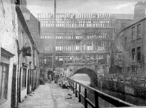 |
| 1902/3 Reconstruction |
The buildings on High Bridge were renovated and put back to their original half-timbered design in 1902/03 under the direction of architect William Watkins. Jettied forward from the first floor are carvings of King Edward VII and Queen Alexandra.
High Bridge remains an architectural gem; Stokes coffee shop is an excellent place to enjoy a coffee. R W Stokes Co. has ground and blended coffee here for over 100 years.
On either side of the shops on High Bridge, there are steep, narrow steps leading toward Lincoln’s Brayford Pool, where barges and ships loaded and unloaded their cargoes. From the footpaths on the west side, you can get an excellent view of the rear of the shops.
*Murder Hole to Glory Hole
In the Middle Ages, the High Bridge acted like a giant funnel. Because the Norman stone archway (built around 1160) was so low and narrow, the river's current naturally trapped floating debris against the masonry.
Unfortunately, this debris frequently included human remains. If someone was murdered or drowned upstream in the Brayford Pool under the cover of night, the current would carry the body straight down to the bridge, where it would become wedged or wash up at the entrance of the dark, claustrophobic tunnel.
The structure of the bridge itself made it incredibly easy to commit a crime unnoticed. Because the bridge has uniquely supported timber-framed houses and shops since the medieval period, anyone looking to get rid of a body could simply drop it directly into the churning waters of the Witham beneath the overhanging buildings.
In the pitch black of the unlit medieval streets, a body dropped into the "hole" would disappear immediately into the dark tunnel, hidden from view. Local lore even suggested that if a criminal had enough luck, the current would carry the evidence all the way downriver toward Boston and out into the Wash, leaving no trace behind in Lincoln.
 |
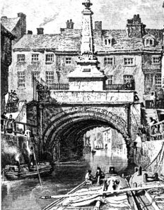
View under the High Bridge at Lincoln
Frederick Nash (1782-1856) |
From Murder to Glory: The shift to the name "The Glory Hole" happened centuries later as the river became a bustling commercial highway. Navigating a large, awkwardly shaped barge through the tight, 22-foot-wide gap required incredible skill; boatmen who successfully squeezed through without damaging their vessel earned the "glory" of a flawless transit.
Today, the darker history has faded into local folklore, and instead of looking for medieval footprints of the macabre, visitors are much more likely to pull up a chair at Stokes High Bridge Cafe right above the old archway for a cup of coffee.
Further Reading: