Search This Blog

Atton Place


Atton Place on Eastgate is one of the oldest houses in Lincoln.  First mentioned in the accounts of the Dean and Chapter in 1441, it was originally a single storey building.  The building was included in a Parliamentary survey of 1649.

Reputedly named after Canon John de Aton (or Acton), Prebendary of Welton Ryval from 1329-1351. who lived here 1324-1326.

The building was re-fronted in a typical Georgian style in the late 18th century, an extra floor was added in the late 19th century, the house was made up of the properties visible in the image, but divided into two properties about the same time.

The building remained a priests' house for many years.  

It later became the County Assembly Rooms and a ladies boarding school, the large ground floor room was cleared for balls and other functions, the room was 40 ft long by 20 ft wide, entered through the central doorway at the front. The County Assembly Rooms moved in 1744 when the new building opened in Bailgate.  The school closed sometime later and then became the Judges Lodgings until 1810.  

For most of the next 100 years the house became a private house, Since the second decade of the 20th century, it has been home to a group of surgeons, an architect and interior designer, and now an estate agent.

People who lived and worked here 
In 1840 it was the home of 31-year-old Harriet Bainbridge's Boarding and Day Academy, her father Thomas' Academy was situated at 1 Michaelgate, her brother George founded the Bainbridges department store in Lincoln High Street.  Harriet married Richard Waddington, an Ironmonger, in early 1841 and later moved to 3 Guildhall Street.  Harriet died in April 1885.

In 1851 Henry Moss, Town councillor silk mercer & master employing 17 hands, lived here with his wife Louisa, 5 children, nephew, 10 employees and 3 servants.  

1857 Miss Thomas - Preparatory school for young gentlemen, formerly at 31 The Park

1932 Douglas Darbyshire, surgeon


Grand House Built on the Sale of Drugs


Francis Jonathan Clarke was a successful Lincoln High Street chemist, to demonstrate his success he commissioned his brother-in-law, Albert Vickers, to design a house to rival Sibthorp’s Canwick Hall, the result: Bracebridge Hall.


The Hall was completed in 1883 in “A brash and chunky High Victorian" (Pevsner)  style.  A Gothic design, the heavy porch faces west onto Newark Road, standing in extensive grounds, stretching from just south of the Gatehouse public house to All Saints Church and bounded by the railway in the east. 

The area around the Hall was wooded with a fish pond of almost half an acre to the south of the Hall, the rest of the grounds, amounting to about 18 acres, was laid out as parkland. The decorated lodge was completed in 1884. 

Lincoln was a major centre of agricultural engineering and heavily polluted with smoke and smells from the many factory and house chimneys in the city. At this time Bracebridge was still a village but within easy reach of Lincoln city centre by the new horse tram service which terminated in the village.

Francis Clarke died in 1888 at the age of 46 after developing serious lung and heart problems.  George Bainbridge the draper was living there in 1894.  In 1918 it became Bracebridge Hall Club (see below) for employees of W Foster & Co and in the 1930s and 1940s it was part ​of Bracebridge Heath (Mental) Hospital.

​Later it became the offices of Gothic Electrical and it is now Grosvenor Hall Care Home.

Between the wars Bracebridge Hall's extensive grounds were reduced for the building of housing on Brant Road and the “Tree Streets” behind the Hall. Recently the grounds have been further reduced until it stands on land hardly bigger than its footprint. 


Bracebridge Hall Club


The Engineer 1918 March 8th


Other Lincoln Houses


Lincoln's Northern Medieval Suburb

When William the Conqueror ordered the building of Lincoln Castle 166 houses, and a church, were demolished.  The people who lived in these houses were moved to an area north of the Roman north gate: this area was named New Port.

Newport Arch with the Cathedral and Bail beyond

A broad road ran north from Newport Arch to the edge of the Newport suburb: this had been the northern approach, Ermine Street, to the City since Roman times.  There was a large market held along this road and it is thought that the first St Nicholas Church was built about this time (mid 12th century) on the northeast corner of Church Lane, then known as Sastan's Gate.  Along with St Peter in Eastgate, St Nicholas' was destroyed in 1643, during the Civil War.  It was used as a battery for an assault on the castle and the lead of the roof was melted to make shot.  The remains of the church were still visible into the early 19th century, but by the middle of the century maps of the area only marked St Nicholas' graveyard.  According to Venables, the wall of the graveyard was constructed from the remains of the church in 1757.  St Nicholas is the patron saint of merchants, travcllers, children, and thieves and was very popular in the middle ages:  merchants travelling between communities would visit his churches to pray for a safe journey.

Possible site of St John Baptist Church, north of Broadway


Close to the site of the present-day Bishop Grosseteste University once stood St John the Baptist church.  This church was built about the same time as St Nicholas', on Chapel Lane, and probably stood in the middle of the road surrounded by the extensive Newport market, it was demolished in 1545, at the time Lincoln 'lost' 36 other churches.

St Hugh's 23 Newport

During the 13th century, a number of priories were established in Lincoln.  The Augustinian friars arrived in Lincoln in 1269 and their priory was built on the corner of Newport and Rasen Lane.  The priory would have been set back from the road: it probably stood where number St Hugh's, 23 Newport now stands, the former boys' home.  The priory had in the region of 30 friars and was surrendered to the bishop of Dover in 1538-9.

Newport was a poor community, having no place of worship, the parishioners had to rely on local clergy to provide communion and other services, the benefice of St Nicholas was preserved by the preaching of an annual sermon in the churchyard and parish business was conducted at "The Turk's Head", a local public house on the corner of Newport and Cecil Street.  

The population of Newport more than tripled between 1801 and 1831 bringing many social problems.  In 1822  Edward James Willson, a local architect had written to Subdean Bayley:   "Newport it seems to me is in more need of civilisation than any other part of the City.   There is no church, no person of the least influence, no checking of the grossest rudeness and insubordination".

The Lincolnshire Advertiser wrote in 1835  "We are led to these remarks from the great increase of the City of Lincoln without Newport Gate, forming as it does a town to itself while there is not a church within a considerable distance to which the population may repair on the Sabbath.   The natural consequence of this is that the inhabitants generally are either complete heathens or violent sectarian bigots.   We do most sincerely trust that some steps will be taken to remedy this crying evil".

St Nicholas' church


In 1838 it was decided a new church would be erected on a site approximately halfway between the sites of the 'lost' churches of St John and St Nicholas.   The architect was George (later Sir George) Gilbert Scott.   He won a competition to design the new St. Nicholas.   The foundation stone was laid in April 1839, and the building was consecrated on the 24thNovember, 1840 by Bishop John Kay.

Behind St Nicholas' church is Newport Cemetery, the original one-acre plot was consecrated 31st December 1855, expanded in 1869 and c 1900.  139 World War I servicemen who were treated at the 4th Northern General Hospital at The Lincoln School (now Lincoln Christ's Hospital School) who did not recover from their injuries were buried in the Commonwealth Graves Commission section at Newport Cemetery.  A further 120 World War II servicemen were buried in the CWGC section

Cross of Sacrifice
By Edward Maufe

Roman remains have found during grave-digging: an inscribed Roman tombstone, Roman cremation urns, amphora handle, samian base, lead figurine.

During the Roman occupation, cemeteries were laid out along main roads outside of towns.  The Roman cemetery at Newport stretched from Rasen Lane to Broadway on both sides of the road

A short distance from St Nicholas' church is Willsons Cottages.  This medieval-looking building was built in the early 18th century out of reclaimed church materials.  It was altered by Edward James Willson, a local architect, in 1834.

Willson's Cottages


On the corner of St John's Road, there is the former St Nicholas' Vicarage.  This building was designed by local architect William Watkins in 1879 for the Rev. F W Blenkin, in Queen Anne Revival style. Retaining many of its original features inside and out, it is now apartments.


St John's House

Lincoln Diocesan Training College was founded in 1862 as a training college for schoolmistresses, it became Bishop Grosseteste College in 1962, becoming Bishop Grosseteste University in 2007


The Radion Cinema opened in July 1939 and closed in July 1960, now Radio Lincolnshire studios, read more about this cinema, and other lost Lincoln cinemas, by clicking here.  The building is on the site of Staunton House built for  Isabella Staunton, the widow of Rev William Job Charlton Staunton (1802-1840) of Staunton in Nottinghamshire. The house was demolished in 1938 for the building of the Radion cinema.


A Sketch of Lincoln in 1810

This description of Lincoln was written by Adam Stark.  He was as critical of the city as some of us are two hundred years later.

"LINCOLN is at present arbitrarily divided into two parts, known by the appellation of Above-hill and Below-hill, though, where this division begins or ends, perhaps none of the inhabitants can determine. The former part is the general residence of the gentry and clergy ; while the latter is mostly inhabited by merchants and tradespeople : the one being, according to the common estimation, considered as the court, and the other as the mercantile part of the city.

An image of Newlandgate, I believe Bargate 
would have been similar to this.


"On entering Lincoln, from the London road, the first object that presents itself is the bar-gate, the Norman south gate of the city, guarded on the outside by the Sincil dyke, which runs from west to east, to some distance below the bar, when it turns southward, past the remains of an old tower, built to defend the angle; but at present of no other use than to serve as a shed for cattle to retire to.

 "On the west of the road, without Bargate, king Edward erected a beautiful cross(1) to the memory of his queen, Eleanor, who died at Harby, a village about seven miles from Lincoin, and was removed by easy stages to Westminster, there to be interred; the king perpetuating her memory by creating a cross at every spot where the corpse rested ; " with the arms of England, Castile, and Pontoys engraven on it." Of this there are now no vestiges, it having been demolished so early as 1643. The cross at Waltham, still remaining, was erected by him on the same occasion."

  • "1291, King Edward took a journey into the North, with his queen, but in the way he lost his greatest worldly felicity, queen Eleanor, who died November 29th, at Harby in Lincolnshire. This accident not only caused excessive grief to him, but brought him back again to inter her body at Westminster; and all along the road in the places where it rested, viz. at Stamford, Waltham, Westcheap, Charing, &c. he erected goodly crosses, engraved with her image, in testimony of his great affection to her, and as memorials of her fidelity and virtues, in which she excelled all womankind as much as she did in dignity."— Daniel."
"The bar-lodge displays none of the taste of former times ; it is evidently a modern erection on the site of the old one, to which, though, it bears no resemblance in appearance, it is analogous in its use; as no person can enter the city, from the south, but through its portal. On passing the gate Lincoln presents the appearance of a long street, in which houses and stables, barns and churches, are intermingled without any regard to. Order,, regularity, or harmony; closed at the further end by a steep hill, covered with buildings, and overlooked by the minster, which, from its size and situation, becomes the principal, object of the scene; while, from contrast, the edifices and churches on the foreground, though in themselves not inconsiderable, shrink from the eye, and are scarcely noticed. Proceeding onwards, the minster, though it rises in effect, decreases in beauty; and that part of the town called above-hill, becomes quite offensive to the eye, from the confusion and jumble it presents: indeed, the most picturesque objects are only so at a certain distance; farther removed, they lose their force; brought nearer, they display too many abrupt lines, and too much harshness of contour to be pleasing. 

"The first object of note within the bar is the church of St. Botolph, which seems here very properly situated, appearing, in this straggling part of the city, like the church of a country village. Some distance, beyond St.Botolph's church, a branch of the Witham. crosses the street, over which are two very inconvenient bridges, disgraceful to the city, and incommodious, if not dangerous, to the passenger. It is surprising there is no attempt at convenience, if improvement is not thought of. , "A little above Gote-bridge," says Leland, "on the east-side of the High street, is a fair guildhall, 'longing to St. Anne's church of the foundation of Burton and Sutton, merchants. A very goodly house, 'longings to Sutton is hard on the north-side of St. Anne's churchyard." By St. Anne's church we are inclined to think that Leland meant St. Andrew's, for there does not appear ever to have been a church dedicated to St. Anne in this city. 

"Near to the site of St. Andrew's(2), stands the "goodly house 'longing to the Suttons;" but which was formerly the palace of John of Gaunt, and had his arms carved in free-stone on the front, till the year 1737. A view of it, as it stood in the beginning of the last century, is preserved in Buck's Antiquities of England. Of the guildhall there are now no vestige."In the suburb, on the west-side of the street," says Gough," is an old house, with a great round arched gate," said to belong to lord Hussey, and out of the bow window of which he was taken to execution, in the 28th year of Henry VIII for being concerned with lord Darcy, sir Robert Constable, sir John Bulmer, sir Thomas Piercy, &c. in a rebellion, in favour of the catholic religion. This house is now taken down, and the place where it stood is almost forgotten.

"Near this range of buildings stands the Unitarian chapel, a small building, with a burying ground adjoining to it. There is nothing particularly interesting in its interior.

""I heard say," observes Leland, "that the lower part of Lincoln town was all marisch, and won by policy, and inhabited for the commodity of the water. This part is called Wigkerford. "A contraction of this name is yet retained, in the term of Wigford, by which this part is known; the appellation might have its origin from this place having been remarkable for the growth of osiers, or withies, from which the term 'wicker-work' is derived, and perhaps, may have been introduced by the Danes; twigs of osiers or willows being in their language expressed by the word vigre. The other part of the name, ford, needs no comment.

"Behind St. Benedict's church there is a small chapel, where a society of the baptist Connexion meets.

"The Methodists have a meeting-house by the water-side, which was built about twenty two years ago, but it is rather too small for the congregation. It is, however, we understand, in contemplation to erect a new one, as soon as the members of the chapel can meet with a situation proper for that purpose.

"Between bar-gate and the stone-bow once stood, according to Leland's account, eleven churches, and a great number of religious houses ; but of these even the sites of the greater part are now forgotten. This street, though straight, wide, commodious, and clean, is yet very deficient in beauty : from the want of uniformity in its buildings; from the high roofs and old gables that continually present themselves to the eye, and the lime trees that are here and there planted in rows, each tree cut round the top, so as to form the appearance of a housemaid's mop inverted, or a large cabbage left sticking upon a naked stem. This is the more to be regretted, as these trees, if left in their natural state, would have produced a useful shade, and an ornament as pleasing and agreeable, as that they now form, by the injudicious application of art, is disagreeable.

"After passing the churches of St. Peter at Goats, St. Mark, and St. Mary, and nearly opposite to St. Benedict's, is a small square, on the east of the street, used as a corn market, which from the celebrity of this place as a mart for grain, appears evidently too confined.

"Lincoln, indeed, with all its advances, does not seem to enjoy that of a good general market place; for Ihe street from the Cornhill to the Butter market, is, on a market day, literally choaked up with stalls and standings, to the great annoyance of passengers, and inconvenience of the neighbouring housekeepers : it is, indeed, a nuisance which calls loudly for removal, and a grievance which it behoves the magistrates seriously and speedily to redress."

(1) It is now known that the Eleanor Cross stood on Swine Green, on the east side of the road south of junction with the High Street and Cross o' Cliff Hill.

(2) Click this link to read more about St Andrew's church


Above the Fascia

As we rush about during our busy days through our towns and cities it is easy to miss an interesting building. “High Streets” throughout the country are almost identical, the only difference being the order of the national stores. Looking above the fascia is a good exercise for the neck muscles and can be a joy to the eyes.


This building at 24-25 Guildhall Street is one such building. Built in the mid 18th century it has been sympathetically maintained and improved over the last 250 years. Dwarfed by its much younger neighbours, it sits confidently exuding the fabric of the history of Lincoln.

Grade II listed, brick-built, stucco front and plain tile roof with two storeys and an attic, it has been two shops for much of its life. To the left, early 20th century shopfront, with pilastered surround and gabled brackets, and late 20th century windows. To the right, mid 20th century shopfront.

First-floor 19th century oriel window flanked by single 20th-century casements. Attic, central dormer with 2 sliding sashes, and to right, a single dormer with a casement.

305-6 is probably the most stunning building on Lincoln's High Street. Designed in 1899 by William Watkins (1835-1926), the architect, of Lincoln, it was built by William Wright for Hewitt Brown & Co in 1900.


Built of brick with terracotta dressings and slate roof with 2 panelled side wall stacks. Designed in Flemish Renaissance Revival. The terracotta dressings were made by the Hathern Station Brick Co. of Loughborough.

Brown & Co began trading from this address in about 1890, becoming Brown Hewitt & Co in 1899. The company continued until about 1909 when Foster and Sons moved into the premises. In the 1920s Currys, the electrical retailer, opened a branch here continuing until 2008 when Fat Face moved in after a £400,000 refit.


You do not need to look up though, to see Curtis and Mawer's stunning building, it is unmissable from whichever direction it is approached. The frontage seen today is from 1922 following a disastrous, fire that almost totally destroyed the building, the entrance door is a survivor from an earlier frontage.

Murder in Lincoln Cathedral

Lincoln and its Cathedral have been the background for many strange and bloody events, but the one described here is probably one of the most tragic.

William de Bramfield was a subdean at Lincoln Cathedral, he would carry out the duties of a Dean in the Dean’s absence, and according to an unknown chronicler William was “a good and a just man”.

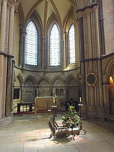
On 25th September 1205 William was kneeling in prayer in St Peter's Chapel on the south side of the lesser Transept in the Cathedral when he was attacked and killed by another subdean who was jealous of his position as one of the Dean’s favourites.

St Peter's Chapel The Location of the Murder

St Peter’s Chapel
The Location of the Murder

There are two stories about the fate of the murderer: one states that William’s servants cut down and hacked at the murderer and threw his body out of the Cathedral, the other states that the murderer was tied to the tail of a horse, dragged to Canwick Hill and there hanged. There was a gibbet near the top of Canwick Hill where criminals who committed their crimes in the City were hanged. The name of the murderer is not known.

King John arrived in Lincoln on the 3rd October 1205, he visited Lincoln Castle but it is not known whether he had any interest in the murder.

Lincoln Cathedral Close


The Cathedral Close was the wealthiest area of medieval Lincoln encouraging “cutpurses”, thieves and murderers to frequent the area at night preying on the people of the Close.

​Medieval Lincoln was divided into three districts: the City, the Bail and the Close*; each was a locally independent self-governing place. The Close is the area surrounding the Cathedral, housing the priests and officials of the Cathedral, together with their servants and those involved in the operation of the Cathedral and the Close. It is believed that the Close came into being at the time of the building of the Cathedral.
*Beaumont Fee was also a self-governing area outside the jurisdiction of the City.

The Dean and Chapter (under the instruction of Oliver, bishop of Lincoln) were granted licenses to crenellate the Close, “for their (the clergy) better safety from night attacks in passing from their houses to the said church”. The first licence was issued on 8th May 1285 for a 12-foot wall (the licence was repeated in 1316) the second was issued in 1318 to raise the wall and add turrets.  The licences required the gates to be open during the day

The Close Wall on Winnowsty Lane
The boundary wall of the Close was intact in 1722 with three of the four towers and is still standing in many places.


The first Lincoln houses to have numbers were in the Close, the “Number Houses”, built after the mid 18th century and somewhat modernised and altered since.

There are over 80 buildings in the Close, most of which are in the ownership of the Cathedral, many of the buildings are of Grade 1, 2 or 2* significance. These are some of the most important:

The main entrance to the Close was Exchequergate, all the gates were double, with a courtyard between the sets of gates, except for Pottergate and Greestone gate, where the incline precluded the use of two gates.

Bishop Alnwick's Tower, 
The Bishop's Palace.

The Bishop’s Palace, a grand medieval series of buildings largely destroyed by the Parliamentarians during the Civil War. Standing on the south side of the Cathedral it is a manifestation of the power and wealth of Lincoln’s medieval bishops.


The Chancellory, on Priorygate opposite the Cathedral, is easily recognised by the grand oriel window on the first floor, it is believed to be Lincoln’s oldest brick building.


The Choristers House, stands near to Priory Gate Arch. Built in 1661 it was converted into 3 residences in 1887

The Deanery, built by Dean, later Bishop, Gravesend in 1254. By the 19th century this building was in a poor state of repair and was replaced on the same site in the mid-1840s.


The Subdeanery stands to the south side of the Exchequer Gate. a medieval building, re-fronted in 1873 by 
J.L.Pearson.  A mosaic and hypocaust was discovered on the site in the 18th century.


Cantilupe Chantry stands opposite the south east door of the Cathedral.  Founded by Nicholas, Lord Cantilupe for a college of priests, to say mass for the souls of the founder and his relations at an altar.

The Vicars’ Court, the entrance is on Greestone Lane, above the stairs.  It was built as a ‘college’ for 20 Vicars Choral¹.  It was originally formed into a quadrangle but many of the other buildings have been removed, Thought to have been erected during the reign of Edward I, but much altered since.


The Vicars’ Stables or Tithe Barn stands below the Vicars’ Court and is a long two storey building built by Bishop Alnwick and John Breton in the 1440s.  Lately used for storage and as a dining hall for the former Girls’ High School on Lindum Road.

    ¹ In medieval times the most important people of the Cathedral were the Canons. often living elsewhere they appointed so-called ‘Vicars Choral’ to deputise for them 


Pottergate, the south gate of the Close.  The gate gets its name from the belief it was built on a Roman pottery.  Over the years it has become a traffic island, first on the west side to relieve traffic congestion in the late 19th century, in the 1930s because corporation buses were too high to pass under.


How Did Lincoln's Streets Get Their Names?

A selection of Lincoln's streets with a description of where their names came from. With the exception of "Historic Streets", this covers the period from about 1830 to 1930. Some of the streets have been lost, indicated with an asterisk (*)

Estate next to Hartsholme Park centred upon Bucknall Avenue
under construction, Boultham Moor, from the south-east, 1951.


Use Ctrl+F to search for street names

Click this link to view Lincoln on the 1912 Ordnance Survey map, zoom in and out using +/- at the top left of the screen

Commercial

Bank Street, the Location of the first Lincoln savings bank., which opened in 1816.
​*Corporation Lane, Here was the Corporation brewhouse.  Located south side of Saltergate about 10 metres west of Bank Street.
*Napoleon Place, Location of the first Lincoln Co-operative Society store.
Tanners’ Lane, The lane of the tanners
*Witham Street, ​Fish Market opened here in 1850, to the west of Corporation Lane

Entertainment

Bullring Terrace, Bull-baiting took place here until the early 19th century. Now Danes Terrace
​​Drury Lane, Home of Lincoln's first theatre 
The Park, Site of Besom Park (pleasure garden) 18th c

Historic Streets

​Baggeholme Road, Prev Baggeholme Lane. From medieval Beggarsholme, a market covering a large part of eastern Lincoln north of the river
Bailgate, name from the bailey of the castle. One of the oldest streets in Lincoln, roughly follows the route of the Roman Ermine Street.
Beaumont Fee, Prev Old Hungate. Beaumont Fee was a self-governing area of Lincoln until the 1830s​
Broadgate, Previously: Broad St. Built 15th/16th century to relieve crowded streets of Lincoln. Built on the Roman Ditch
​Butchery Street, ​Prev St Lawrence Lane. The Butchery was a market for butchers which stood where the Ye Olde Crown is. Now Clasketgate.
Clasketgate, Claxlet Gate (1326). Knights’ Templars were held in the Claxlet gatehouse that fronted onto Broadgate, awaiting trial after the dissolution of their order.
Cornhill, On site of St Johns Churchyard. Corn market here since 16th century.
Coultham Street, Existed since 1698 Coltham, a Lincolnshire Family
*Coultham Terrace, Coltham, a Lincolnshire Family
Croft Street, Built on St Hughs Croft. previously Croft Lane
Cross O' Cliff Hill, The Cross On the Hill, Cross was once at the top of the South Common where civic dignitaries would greet royal visitors before leading them into Lincoln.
Drapery, The, ​Where cloth was made, prev known as the Parmentaria, now ​St Martins Lane
East Bight, ​Probably dates back to Romans, prev Tom a Bit Lane, Tommabeck Lane
Friars Lane, ​Near site of Dominican priory.
​Grantham Street, Previously Grantham Lane and Brauncegate. The Grantham family's house was near or at the Cardinal's Hat
Guildhall Street, ​Previously Baxtergate (the street of the bakers), Newland Street
High Street, previously Briggate and Micklegate
​Hungate, ​"The street of the dogs (hounds)". It is thought hunting dogs were kennelled here
Long Leys Road, ​"Long strips of meadow"
​Lucy Tower Street, ​Previously Poor Alley. The name refers to the castle tower visible from the street
Michaelgate, ​Near St Michael on the Mount Church, prev medieval Parchemingate (The Parchment makers.) and later Fish Hill (the fish market was in the grounds of the old County Hospital)
Mint Lane, ​Mint Lane joined the High Street until renamed Mint Street and extended to Newland
​Mint Street, It is believed the Lincoln Mint was on this street
​Motherby Hill,​ Previously Motherby Footgate
​Nettleham Road, an ancient road known as Nettelhamgate in 12th/13th centuries
Newland, Land reclaimed c 14th century
Newport, ​Citizens dispossessed by the building of the castle were moved to this area in the 11th century. Roman Hermin or Ermine Street
​Pottergate, ​"The street of the potters", prior to the building of New Road (later Lindum Road), Pottergate led from Clasketgate
Rampart, The, ​​a raised causeway 9 feet above the surrounding marshy land from St Mary’s Street to Bargate, a bridge first built by the Romans to cross the low-lying marshland.
Rasen Lane, named after the family of that name, possibly the ancient Sextongate
Rosemary Lane, ​Previously Lime Lane and possibly Finkle Street
Silver Street, "The street of the Silversmiths", close to the supposed location of the medieval Lincoln mint.
Saltergate, ​"The street of the salters". Known as Saltergate in the 13th century
Stamp End, ​"The place by the weir or dam". Medieval road
​​Steep Hill, ​follows the route of Ermine Street, steepest part was previously Poultry Hill
Strait, ​"The narrow path or passage."
St Leonards Lane, ​has existed since 14th C, St Leonard’s Church was on the site of the school
Tentercroft Street, A place where new cloth was tented (stretched)
Unity Square, Previously Pig Market and Jobbers Square
Water Lane, Previously Walkergate
Westgate, Previously St Paul’s Lane. St Paul’s Lane is now just the part that runs parallel with Bailgate
West Parade, Previously Clay Lane, Wong Lane
​Winnowsty Lane, Previously Wainewell St. 13th century, renamed Swine Sty Lane, early 19th c.  Winnowsty Lane once continued to Lindum Terrace (thought to be known as Wintergate) following the line of the lower part of Sewell Road, the rest of it has been lost due to quarrying. Wainwell Gate was part of Wragby Road as far as St Giles Avenue. The meaning of Winnowsty is "the path or Lane the leads to Wainwell". Wainwell means "Waggon Spring"

Pubs

Anchor Street, Next to Anchor public house, previously the Blue Anchor p.h.
​Magpies Square, Magpies public house on north east side of Magpies bridge (now Thorngate bridge)
Shakespeare Street, Opposite the Shakespeare public house.
Swan Street, Previously White Swan Yard

Royal & Peerage

Alexandra Terrace,Princess Alexandra of Schleswig-Holstein-Sonderburg-Glücksburg, married Edward, Prince of Wales in 1863.
Arthur Street, Prince Arthur, son of Queen Victoria and Prince Albert
*Baron Street, *Barton Street, Bentinck Street, *Clumber Street, ​*Duke Street, ​*Earl Street, Welbeck Street, Dukes of Portland - Bentinck family. Land previously owned by the Bentincks.
*Eleanor Street, *Eleanor Terrace, Queen Eleanor, first wife of Edward I, died at Harby in 1290. Her viscera were removed and placed in a tomb at Lincoln Cathedral. Her corpse was embalmed at St Katherine’s Priory.
Gaunt Street, John O' Gaunt's "Palace" was nearby

Local people

​Addison DriveDr Christopher Addison, the Minister of Health, formulated what became known as the Addison Act in 1919, to provide council housing.  St Giles was the first major housing estate in Lincoln.  He was born in Hogsthorpe in 1869.
Allison Road, (now Sewell Road) and Allison Street, John Allison, Lincoln merchant
Ashlin Grove, Peter Ashlin, evangelist.
Beevor Street, Elizabeth Beevor, wife of Rev C C Ellison
​Cannon Street, ​Bernard Cannon, Glue manufacturer and Mayor in 1880, Alderman. Lived in Lincoln for many years but born in Dublin.
​Carline Road, Richard Carline. Solicitor and Mayor 1847
Chaplin Street, Built on land owned by Henry Chaplin
Charlesworth Street, Dr Edward Charlesworth, Lincoln Lunatic Asylum
Coulson Road, William Coulson, president of Lincoln Co-operative Society 1887 & 1892
​Curle Avenue, ​ Muriel Curle wife of Joseph Seward Ruston
Ellison Street, The family of canal and river lessees, and bankers. Lived at Boultham Hall
Dixon Street, Dixon Street named after my great x3 grandfather John Stanfield Dixon, maltster, corn merchant and St Botolphs mover-and-shaker, who lived round the corner at 76 High Street (still there with arched entranceway).  (Thank you Anonymous)
​*Fenton Place East & West, The Fenton family, James Fenton
Foster Street, ​William Foster, Miller & Engineer, the company he founded later designed and built the first operational military tank.
​Garmston Street, Elizabeth Garmston d.1798 left a sum of money for the poor or St Martin's parish.
Gibbeson Street, ​Richard Gibbeson, Mayor of Lincoln 1794
Gresham Street, ​William Gresham, Lincoln Sheriff, died 1857
​Hartley Street, George & Joseph Hartley, presidents of Lincoln Co-operative Society 1872 and 1878, houses built by Lincoln Co-operative Society.
Hermit Street, ​Henry Chaplin's 1867 Derby winner, Chaplin stabled horses nearby
Hewson Road, William Hewson, president of Lincoln Co-operative Society 1897 & 1905
Hood Street, The Hood family of Nettleham Hall
Horton Street, a well-known Lincoln family of builders.
James Street, previously Vinegar Lane, renamed by Col James Bromhead who lived in Burgersh Chantry.
King Street, Named after William King, his house stood on the site of King Street in 1861.
​McInnes Street, Duncan McInnes, secretary of Lincoln Co-operative Society 1882-1903
​Melville Street, ​the Leslie-Melville family of Branston
Monson Street, Monson family of Burton by Lincoln
​Nelthorpe Street, ​Nelthorp family (no 'e' at the end of the surname)
Robey Street, Robert Robey of Robey & Co
Rudgard Lane, Lincoln Brewers and Maltsters, Corporation Aldermen.
Salthouse Lane, ​Samuel Salt, shoeing smith, "The house of the Salt family", not referring to the condiment.
​Scorer Street, William Scorer, architect and uncle to Hugh Segar "SamScorer FRIBA FRSA.
Sewells Road, ​Matthew Sewell, mayor of Lincoln in 1814, Previously Allison Road
Sewells Walk, Matthew Sewell, mayor of Lincoln in 1814
Sibthorp Street, The Sibthorp family of Canwick
Tempest Street, The Tempest Family of Coleby.
Trollope Street, Arthur Trollope, Captain Commandant 1st Lincolnshire Volunteers, second cousin of Anthony Trollope, the novelist.
Winn Street, Thomas Winn, mayor 1830, d 1855
Wordsworth Street, Christopher Wordsworth, Bishop of Lincoln (1869-1885)

Military

*Beresford Street, William Beresford, Peninsular War General
Blenheim Road, Battle of Blenheim 1704
​Bunkers Hill, American Independence Battle of 1775 near Boston USA. The road was named long before the houses were built.
*Clinton Street, British general during American War of Independence
Colenso Terrace, Battle of the Second Boer War, Lincolnshire Regiment 1899
​Depot Street, a military depot nearby, was built in 1806 during the Napoleonic wars, contained 6000 arms and guarded by disabled men of the Royal Artillery. Later part of Dawbers brewery. Demolished early 20th C.
​*Hardinge Street, ​British General Napoleonic Wars
Jellicoe Avenue, Admiral of the Fleet John Rushworth Jellicoe, 1st Earl Jellicoe, victor at the Battle of Jutland in WWI
​*Picton Street, British Lieutenant-General died at Battle of Waterloo
*Raglan Street, Lord Raglan, British Field Marshall at the Peninsular War, 100 Days War and Crimean War.

Miscellaneous

Boultham Avenue, Previously a private road to Boultham Hall
Cranwell Street, Cranwell House was nearby on High Street.
Freeschool Lane, ​Free School established at Greyfriars by Robert Monson in 1568. Road name dates from 1833
​Great Northern Terrace, Great Northern Railway. The land between Gt Northern Terrace and Pelham Street was previously owned by Francis Edmund Franklin
Lindum Road, ​Formerly New Road, was built in 1786, renamed by the Lighting and Paving Commissioners in 1831
​Lindum Terrace, ​Previously Hill Top Road, probably the medieval Wintergate
​Longdales Road, ​Long Dales is a very old name, the road is much more recent. 1872 a few houses built but most were built in the inter-war years
Mill Lane, ​Leading to Le Talls Mill on Princess Street
​Mill Road, Five of the nine Lincoln Edge windmills were sited here
Milman Road, Previously Love Lane
Monks Road, Previously Monks Lane
*Nix Row, Probably built by Edward Nix, Stonemason, lived at 21 Newport in 1851
St Catherine's Grove, Built by Lincoln Co-operative Society
Toronto Street, Built by William Priestley, Born in Lincoln and emigrated to Ontario, Canada in late 1870s, returned to Lincoln about 20 years later and bought land south of Monks Road, He built Portland House at the end of Toronto Street for him and his family. Also built Walmer Street.


Can you add to this list?


The Romans at Lincoln

When the Romans arrived in Britain in AD43 strong trading ties had existed almost since Julius Caesar's abortive invasion. Rather than seen as invaders, in many places the British tribes welcomed the Romans, as did the Corieltauvi at Lincoln. The capital city of the Corieltauvi was Leicester, it came under Roman rule in AD44 and in AD45 the Roman 9th Hispanic Legion marched northeast to Lincoln.


Newport Arch in 1793

The Legion had a strength of about 9,000 men who were not only soldiers but also had skills necessary for supporting an army on the move. Using these skills it is thought that they built a palisaded fort on what is now the South Common. The Witham Valley was, at that time, marsh and difficult to cross, this problem was solved by the building of a causeway nine feet above ground level, following roughly the line of Lincoln's present-day High Street.

In AD60 a fort was built on the crest of the hill on the north side of the valley and was known as Lindum. The position of this new fort gave the Romans a strategic advantage: they had an almost 180-degree view of the surrounding countryside from south-east to the north-west of the fort.

The 9th Legion (Hispana*) moved to York in AD71, the 2nd Legion occupied the fortress until about AD77.  and Lindum became a Colonia in AD80, a place for veteran soldiers retired after 25 years of service, they were given a plot of land on condition they gave military service whenever required.

Lindum was of a typical Roman town design, a rectangular plan and dissected by two main roads, east-west and Ermine Street, south-north, covering an area of about 17 hectares.  Bailgate roughly follows the line of Ermine Street but has been reshaped over the years by householders using the Roman road as the foundation for their properties.  


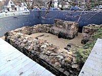
Eastgate, Lincoln
Eastgate curves south after passing the
remains of the Roman east gate, this
may have been re-aligned by the Normans
 to make access to the castle easier
Northern bastion of Lincoln's Roman east gate
Northern bastion of the Roman
east gate


A Discovery on Lincoln High Street
200 years ago.

Lincoln was an important Roman town, the Foss Way and Ermine Street met south of the town.  It was an agricultural centre the Foss Dyke was constructed between Lincoln and the River Trent at Torksey to send produce to other parts of Roman Britain.

Lindum Colonia was first surrounded by walls about 3 feet high and gates at the four points of the compass, but in the 3rd century the height of the walls was raised and substantial gates were built because of the threat of attack from the tribes of northern Europe and Scotland. Newport Arch is the only gate still existing, it was the north gate of the upper town. The west gate was buried beneath the Norman walls of the castle, and in 1836 it was re-discovered in near perfect condition but had to be reburied because the weight of the wall was causing the gate to collapse. Sadly, the east and south gates were destroyed during the late 18th century.


* The 9th legion gained the name Hispana after distinguished service in Spain