Search This Blog

Byards Leap - A Lincolnshire Legend

The legend of Bayard's Leap is locally well-known and is timeless, over the years many versions of the story have been retold; the difference is the hero of the tales, he is a knight, a soldier or a shepherd.  The story I have reproduced below the hero is a shepherd:

"On the old Roman road, called ' Ermine Street,' or ' The High Dyke,' . . . —and at a distance of some three miles from Ancaster, a Roman station . . . —and in the angle formed by the Sleaford and Newark road, which there crosses the Roman road — stands a solitary farm-house; its solitude only relieved by two cottages distant about one hundred yards, on the same side of the great highway, and, more recently erected, a small school building on its opposite side.

"Solitary in its position, its civil status also was formerly isolated, since it belongs to what was an extra-parochial farm, at the north-west corner of Rauceby, sometimes returned with the parish of Cranwell, sometimes with that of Leadenham ; but latterly (under the Act, 20 Victoria, cap. 16) constituted a separate parish in its own right.

"Close by the entrance gateway to this farm-house, on the roadside, is a block of stone, such as not uncommonly may be seen near old houses of the kind, forming two steps, from which a rider mounted his horse. This stone is inscribed with the words ' Byard's Leap.'

"Not less singular are the circumstances which are said to have given rise to the name "of ' Byard's (or ' Bayard's ') Leap,' or the Leap of the horse ' Bayard.' ... It [the Leap] is situated in the midst of what was once a lonely tract of high land, almost a waste, extending for many miles, and called Ancaster Heath. . . . The pedestrian who follows the footpath which runs along the Eastern side of the great Roman highway will observe, at a distance of some fifty yards northwards from the farmhouse of Byard's Leap, and near a pond by the roadside, four very large iron horseshoes, embedded in the soil. If he measures the distance of these shoes from the pond he will find that it is twenty paces or sixty feet, and sixty feet was the length of Byard's Leap. . . . Opposite the farm of ' Bayard's Leap ' is a plantation . . . consisting chiefly of trees of recent growth; but probably there formerly existed an older growth, whose pristine shades were more adapted to harbour weird spirits.  Within that wood, inhabiting, as it is said, a cave, but more likely a deserted quarry of the famed Ancaster stone of the district (such places of abode being still used), there lived the pest and terror of the countryside in the person of an old woman, known far and wide as, par excellence, the witch ... a dangerous character was the old beldame to anyone who ventured to thwart her or cross her path. ...
byard's leap signboard
An alternative tale
"If the old woman was denied anything which she craved, of her better-to-do neighbours they were certain speedily to suffer for it. . . . Neither man nor beast is secure from her spells. ... At length, a child having been stillborn in a cottage from which the old woman had been turned away without receiving what she asked for, the indignation ripens, and a plan is proposed, by which it is hoped that the witch's power may be put an end to, while the act shall seem to be of her own originating. The shepherd of the farm has been on something like intimate terms with the old woman, ... as is surmised . . . having had illicit dealings with her, the result, however, being that closer acquaintance with her has in no wise enkindled affection: and although afraid to ' break ' with her ... he would yet greatly rejoice ... if he could terminate the unpleasant thraldom of her influence. . . . By a sort of lottery, the shepherd is selected for the enterprise. He is to lead out the farm horses to water in the evening, at the pond by the roadside, opposite to which is the hag's den.  He is to throw a stone into the water as the horses are drinking, and whichever horse then raises its head first, he is to mount. He is to be armed with a two-edged knife.  He is to call to the old woman to come out and mount behind him. He is to stab her when she has done so as if in self-defence on her springing up behind him; it is hoped that in the struggle she will be drowned; the not unfrequent end of witches. At the appointed time he proceeds to carry out these instructions. The horses are led to the water, the stone is thrown into the pond. The first horse that raises his head on hearing the splash is the blind Bayard; a providential circumstance, since it is likely that any horse which could see would shrink from contact with the witch. 


"He mounts the horse Bayard.  He calls out to the old woman, asking her to come and ride behind him. Her reply (which has been preserved) is, ' Wait till I've buckled my shoes and suckled the cubs, and I'll be with you.' He waits, and in due time she comes forth. At his bidding, she mounts behind him.  He at once plunges his knife into her breast. The old hag, in her agony, clutches at the horse's back with the long sharp nails of her fingers. The horse in alarm makes one wild, sudden bound, which lands him full sixty feet from the spot. The witch falls back into the pond and is drowned, so her career is ended.


"Tradition says that the horse made a second bound, equal in length to the first, and which brought him to the corner of the cottages which stand further on by the side of the road ; but only the first is marked by the four huge horse-shoes, which are carefully preserved, in situ, as described above, as standing evidence and memorial of ' Bayard's Leap.' . . . It should here be stated that considerable variations from the foregoing version of the legend exist, as is usually the case with such narratives, in the form of oral tradition still floating in the neighbourhood. For instance, the personality of the hero himself varies from that of a knight-errant of the age of chivalry to that of an ordinary cavalry soldier of a more recent period. . ."

"The Legend of Byard's Leap" - Rev J Conway Walter

(Bayard is Old English meaning horse)

For many years the leap and landing points were marked by holes in the ground, these holes were probably marked parish boundaries and would be re-established at the annual "beating of the bounds".  


In the mid-19th century the then Colonel Reeve of Leadenham had three sets of horseshoes made by Bradley and Howitt of Newark.  The horseshoes were set in concrete and set in the legendary positions.
In the early 1960s the A17, a trunk road from King's Lynn to the A1, was straightened at Byard's Leap and the third set of horseshoes was in the direct route of the road.  This set of horseshoes was put into storage at Wilsford, several years later they were returned and placed near to Byard's Leap Cottages on the north side of the A17.  

Map showing the re-alignment of the A17

Reproduced with the permission of the National Library of Scotland

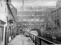
The Old House on Corporation Street

The opening of Yarborough Road in the 1880s and growth of housing in West Parade had a dramatic effect on traffic entering the northern part of the High Street.  The City Corporation took the decision to build a new road to join West Parade to the High Street and across to Butchery Street (now known as Clasketgate).  This road is Corporation Street.

Unfortunately, this once grand house stood in the way and had to be demolished.  It was a large, well-built house, originally enclosing three sides of a square, leaving the south side open; the east side, next to the High Street, had been altered over the years but the north and west sides remained comparatively unaltered. The main staircase was inside the north-west angle, and led up to large rooms on the first floor, in one of which, the one with a four-light mullioned window in the photo above, had some good oak panelling of early 17th-century date. The room with the seven-light window (three of which are blocked) of late Tudor date, was also large, and above all was a false roof running around the north and west sides. The east side was supported by three large buttresses and can be seen in the view, the centre one being the best and strongest.


The house was probably built as a private house and was about 50 yards north of Park Lane.  It is obvious from the photo that the house had suffered many years of neglect.

More Lincoln Houses

The Blue Inns and the Living Sign

Inn Signs - At Grantham in Lincolnshire, from the eccentricity of the lord of the manor, who formerly possessed the majority of the houses in the town, there is at the present time the following inns that have the word BLUE attached to their signs: viz.-- , Blue Boat, Blue Sheep, Blue Bull, Blue Ram, Blue Lion, Blue Bell, Blue Cow, Blue Boar, Blue Horse, and Blue Inn. By way of completing this blue catalogue, a wag, whose house belonged to himself, and who resided near the residence of his lordship, a few years ago, actually had the Blue Ass, placed on his sign.
In Castlegate, Grantham, near the church, a Bee-hive is substituted for a sign-board, with the following inscription underneath:

Stop! Traveller, this wond'rous sign explore,
And say when thou hast viewed it o'er,
Grantham, now, two-rarities are thine,
A lofty steeple, and a living sign.

- The Mirror of Literature, Amusement, and Instruction, SATURDAY, JUNE 1, 1833.


The Castle, the King of France and the Dolphins

The Castle
Somerton Castle in 1801


Antony Bek, Bishop of Durham, inherited Somerton from his mother, Eva de Grey, in the mid 13th century, at the time there was a grange on the site. Bek obtained a licence to crenellate at Somerton in 1281. It was built in the style of Welsh castles of the time, quadrangular with circular towers at the angles and linking curtain walls. It was not built as a defensive structure but rather as a demonstration of power and wealth, and an administrative centre for the surrounding country.

The length of the walls was as follows: North 230 ft, South 210.5 ft, East 276.5 ft, West 251 ft.

Bek died in 1311 and Edward I took possession of the castle, granting it to William de Beaumont.
The King of France
On the 20th September 1356, during the 100 Years War, Edward, the Black Prince, against massive odds beat and captured King John II, John the Good, at the Battle of Poitiers.

John was brought to England in May 1357, the party landed at Sandwich and travelled onto Canterbury where, after making offerings at the shrine of St Thomas Becket, they rested for the night. Following two more overnight stops, the party arrived in London on 24th May. John, on his white charger, rode through London to the palace of the Savoy. Late in the summer John and Prince Philip visited Windsor Castle where they enjoyed the sport of hunting.

Towards the end of 1358, a series of restrictions were placed on the captives. On 12th December 1358, Roger de Beauchamp was ordered to watch the captives with 69 men-at-arms and moved them to Somerton Castle, 10 miles south of Lincoln. Four large casks of wine were transported there and a ship carried his goods to Lincolnshire by sea. John only remained there for four months and was transferred to Hertford Castle on 4th April 1359.

King Edward III decided to move his important captives back to Somerton; and appointed William, Baron D'Eyncourt, custodian of the Royal prisoners. Two Baronets Sir John de Kirketon, and Sir John D'Eyncourt, and two knights Sir William Colevill and Sir Saier de Rochford, agreed to the safe conduct of the king of France from Hertford Castle to Somerton. It was agreed that Lord D'Eyncourt and his associates should supply, as a guard during the journey, 22 men-at-arms, 20 archers, and 2 gaytes, all of whom were to dine at the Lord D'Eyncourt's table, at the cost of the king, and were to receive daily the following wages: each of the baronets 4s., each of the knights 2s., each of the esquires 12d., each of the horse archers 6d., each of the foot archers 3d., and each of the gaytes 6d., amounting to 39s. per day; whilst, to make up the sum to 40s. the Lord D'Eyncourt was to have an additional 1s. per day. In accordance with this order, D'Eyncourt commenced the removal of the royal captives from Hertford to Somerton on Monday, the 29th of July, 1359, dining at Puckeridge, and sleeping at Royston. On Tuesday, the travellers dined at Croxton, and slept at Huntingdon, remaining there until the following day. On Thursday they dined at " Gerston" (Glatton?) and slept at Stamford, where they remained over the Friday. On Saturday they dined at Easton, slept at Grantham, and stayed there until after dinner on Saturday, August 4th. After leaving Grantham, and following the straight course of the Roman Ermine Street in the evening they arrived at Somerton. Most of the journey would have followed Ermine Street. 

In February 1360 there were concerns about a possible French invasion to attempt to release the captives, Edward III ordered that they should be imprisoned in the Tower of London.

Following an agreement about payment of a ransom, King John and Prince Philip were released on the 30th June 1360. The King agreed to send hostages to guarantee the payment of the ransom.

The King and his entourage arrived at Dover on 5th July, where he was entertained by the Black Prince. He sailed from Dover in July arriving in Calais where he was held for three months while he obtained the first instalment of the ransom.


1850 Plan of the castle
and earthworks. 
Drawn by J S Padley


Louis, the Duke of Anjou and son of King John, the most important of the hostages, escaped from his captivity and returned to France with other hostages. King John was mortified when he learned of the escape, returned to England and offered himself as a hostage. The palace of Savoy was again his residence, sadly he did not long survive his generous act. Following a short illness in the spring of 1364, John passed away in April 1364, after having made a will, at the age of 44.

Somerton Castle remained in royal ownership until it was sold by Charles I in 1628.


Samuel and Nathaniel Buck's engraving of 
Somerton Castle, 1726.


Today the south-east tower is complete, the house attached to it is said to be Elizabethan (but I suspect it was built in the 19th century). The northeast tower is vaulted, and supported by a single pillar, from which to the sides spring twelve arches forming as many niches in the walls. The lower part of the south-west tower is still visible. The north-west tower and curtain walling no longer exist, probably removed for the development of the farm buildings in the 19th century.

There are remains of moats around the castle with a double moat and earth banks to the south.


The remains of the Northeast tower in 1801


Northeast tower vaulting


The Dolphins

The Dolphins was an Inn northeast of Lincoln Cathedral.  The attached notice was displayed in the inn for many years. There are a few inaccuracies in the notice; the Dauphin wasn't held with the King, it was Prince Philip and Saier de Rochford was not the owner of the castle.  

Was the name a misspelling or an insult to the French?
 A modern copy of the notice
            in the Dolphins


The Dolphins Inn, removed by Albert Shuttleworth
in 1892 to improve his view of Lincoln Cathedral
from his Eastgate House


Recent images of the Castle and Earthworks 
Somerton Castle was bought a few years ago by a local businessman and is now being restored.


For our Facebook group, please go to:

The Church that Moved – or did it?


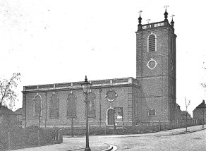
The church that stood on the corner of High Street and Silver Street was known as St Peter at Arches, the “Arches” came from its position close to The Stonebow.
There is evidence that by the 11th Century two St Peters stood in the churchyard: St Peter at Arches and St Peter at Pleas (so-called because of its proximity to the Moot Stone which was located near Ruddock's shop).
In 1719 an application for a brief for rebuilding the church of St Peter at Arches was made to the City Council.  A loan of 1000 shillings ( the equivalent of about £4,500 today) was taken up at interest by the city for the rebuilding of the church, repayable over 10 years.  The church was built by William Smith and consecrated in 1724 as the Corporation church.
Some notes from the Corporation records:
In 1722 Lord Thanet donated 40s. towards the rebuilding.
In 1723 a further 600s. was voted by the Corporation for the completion of the church
In 1738 “two persons” gave 8s. for a clock and chimes at St Peter's
19th century drawing of St Peter at Arches
18th-century drawing of St Peter at Arches Church
In 1786 4s. granted in addition to 6s. already granted to be distributed by the minister and churchwardens of St. Peter-at-Arches among such persons as shall sing or perform upon any musical instrument in that church during divine service on the Lord’s day.
St Peter at Arches was closed in 1929 and demolished in 1933.
St Giles church was designed by W G Watkins and built in 1936 on the new St Giles estate northeast of Lincoln in the same style as St Peter at Arches.  Much of the decorative stonework was used but the structural stone was replaced by brick.  It can be seen from the pictures that an additional bay was added to the building of St Giles Church.
St Giles Church shortly after its completion in 1936
St Giles Church shortly after completion in 1936

The 1794 organ, built by J Lincoln of London and restored by “Father” Henry Willis of Henry Willis & Sons, was also moved to St Giles and installed by 
Cousans, Sons and Co.  The 8 bells of 1728 were installed together with the peal board of 1756, the oldest surviving in the county
St Giles Church is quite unique in that it is one of the few churches with its altar at the west end of the church, the probable reason for this is that it was built opposite St Giles Junior School with its main door facing the school.

The Dawber window removed from St Peter at Arches


Lincoln's High Bridge, Unique In This Country

 
High Bridge on Lincoln’s High Street is the oldest surviving bridge with buildings on, in this country. It marks the spot where the Roman Ermine Street crossed the Witham by way of a ford, a bridge was built c2nd century.

The river was much wider than today and High Bridge was thought to be made of five arches, today only one arch remains.

There were many bridges like High Bridge in the middle ages, London Bridge for example, but all the others have long since disappeared, the only other bridges with buildings on in England are Frome Bridge dating from 1667 and Bath’s Pulteney Bridge of 1773.


At the Reformation there were as many as 52 religious buildings in Lincoln, one of them was the chapel dedicated St Thomas the Martyr which stood on the eastern side over the vaulted arch of the bridge. The chapel was paid for by Lincoln Corporation c 1200. Following the Reformation the Corporation converted the chapel into a house, it was let as a hall to the Company of Tanners and Butchers, and finally a warehouse until it was demolished in 1763. An obelisk was then erected which was also a water conduit that brought water from near the end of Monks Road. The original pipes for this were laid by the brothers of Greyfriars in the early 16th century. The obelisk was removed in 1939 due to concerns about the strength of the arch supporting it. A reconstruction of the obelisk can be seen at St Mark's Shopping Centre.

The Glory Hole,
showing medieval ribbing
The river route under the bridge was once named "The Murder Hole", bodies could be dropped in the water here without being seen and, with luck, would float downriver to Boston and onto the Wash. 

The maximum height of 9 feet and width of 22 feet together with an awkward angle under the bridge sets a limit on the size of vessels that can use the Witham from Brayford Pool to Boston, and vice versa. It now has the much happier name "The Glory Hole", this may come from the difficulty of getting large vessels through, there would be some "glory" when a boatman made it through!


Until the 1790’s the river was not navigable all year, in summer the bed of the river was often dry; there are tales of horse and coaches driven across the river in summer just west of High Bridge. Joseph Banks (1743-1820), the botanist and naturalist had commissioned the building of the Horncastle Canal, he could see that revenues on his canal would by severely restricted by the problems at High Bridge. The Corporation was reluctant to improve the navigation under the bridge because they earned porterage from the trans-shipping of cargoes. This reluctance forced Joseph Banks to look at alternative routes. William Jessop (1745-1814), the noted canal builder (locally he built the Grantham and Sleaford canals), was commissioned to investigate a likely route. Jessop put forward a scheme to route barges from Brayford Pool southwards on the upper Witham to Sincil Drain, in effect by-passing Lincoln. The Corporation realised this would be devastating for the economy of the city and, in 1795, the bed of the river beneath High Bridge was lowered at the expense of the proprietors of the Horncastle Canal. To celebrate the event boards were laid on the dry river bed and a dance took place under the bridge.

1902/3 Reconstruction
The buildings on High Bridge were renovated and put back to their original half-timbered design in 1902/3 under the direction of architect William Watkins. Jettied forward of the first-floor are carvings of King Edward VII and Queen Alexandra.


The High Bridge remains an architectural gem, Stokes coffee shop is an excellent place to enjoy a coffee. R W Stokes Co. has ground and blended coffee here for over 100 years.


Either side of the shops on High Bridge there are steep narrow steps leading towards Lincoln’s Brayford Pool, where barges and ships loaded and unloaded their cargoes. From the footpaths on the west side you can get an excellent view of the rear of the shops.


Further Reading:


The Lost Houses of Lincolnshire - Haverholme Priory

Haverholme is 4 1/2 miles north east of Sleaford. Referred to in Domesday Book as Holm, later becoming Hufreholme and then Hafreholm.

Alexander, Bishop of Lincoln offered a marshy island site near Sleaford to Abbot Gervase of Fountains Abbey in 1137. Buildings were erected by 1139 and a band of Cistercian monks were sent from Fountains to take possession. The monks were unhappy with the site and Bishop Alexander offered them land in the north of the county, where Louth Park Abbey was built.

Alexander then offered Haverholme to Gilbert of Sempringham. Gilbert founded the only English religious order and was unique in accepting men and women into the same houses albeit in separate accommodation.

The number of nuns at Sempringham was increasing and the buildings at Haverholme were ready for occupation. The priory at Haverholme was dedicated to St Mary. St. Gilbert sent nuns, lay sisters and lay brothers to Haverholme, but at first they suffered severely from poverty, Simon Tuchet granted the priory lands in nearby Ashby in 1140. Later benefactors included Henry II, Roger Mowbray and Roger de Lacey.

In 1164 Thomas Becket, Archbishop of Canterbury, "from his angry sovereign in fear of his life, he took refuge in the hermitage belonging to Haverholme Priory, on the edge of the fen, under the guidance of a monk who knew the country."

Gilbert had limited the numbers in the house to 100 nuns and lay sisters, and 50 canons and lay brothers. At the Dissolution the members of the Priory had dwindled down to a small number.

The deed of surrender is dated September 5th, 1539, and by it William Hall, the Prior, and six canons gave up the Priory and all the estates belonging to the Priory, and in return, together with the prioress and seven nuns, received pensions for life varying from £4 to £2 per annum.

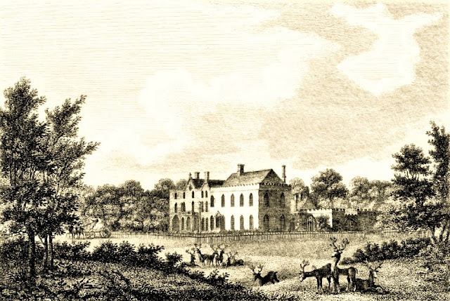
The Priory was granted to Edward Lord Clinton, who, by the King's licence, granted half the manor to Robert Carre in 1544, and the other half to William Thorold. The property passed through several owners until it was bought by Sir Samuel Gordon, 1st Baronet in 1763. The property passed, on his death, to Sir Jenison William Gordon, 2nd Baronet. In 1788 Sir Jenison improved and enlarged the building.
The Priory, south and east aspects c. 1800

Sir Jenison died in 1831 and bequeathed the Priory to George William Finch-Hatton, 10th Earl of Winchilsea, 5th Earl of Nottingham. Henry Edward Kendall was commissioned to redesign the Priory, the work being completed in 1835. A resemblance to Haverholme Priory can be seen in Carre's Hospital at Sleaford, another of Kendall's designs.

Henry Stormont Finch-Hatton, 13th Earl, was the last owner of the Priory. After World War I, in common with many landed families, the 13th Earl decided to put the Haverholme Priory Estate up for auction.


South aspect c 1925


East end of south aspect and Orangery


The auctioneers were the well-known local firm of Earl and Lawrence and took place on Monday, 9th August 1926 at the Corn Exchange, Sleaford. The Priory sold for £5,400 to a Mr Caley of Manchester who, after the departure of the Finch-Hatton's by 11th October, would demolish the building. A sad end to a fine country house.

There is a story that circulates in the local Sleaford area that the Priory was bought by an American heiress who intended to rebuild it in the United States. The story goes on, she was killed in a train crash, the stone was stored at Liverpool docks and was eventually used to repair dock walls. Sorry to dispel the illusion, it's not true.


Henry S Finch-Hatton's second son was Denys Finch-Hatton, Denys was a white game hunter in East Africa and was killed in a flying accident in 1931. He was the subject of the film "Out of Africa", starring Robert Redford and Meryl Streep.


St Andrew's Church, Calceby.

In my pre-driving days, I used to travel, with my parents at weekends in the summer, from Lincoln to Mablethorpe via Belchford and Alford. On the crest of a hillock at the side of the Bluestone Heath Road are some ruins. Despite asking a local and checking OS maps, we could not find out what it was.

Remains of St Andrew's Church, Calceby


Fast forward more years than I care to remember, I now know it's the remains of St Andrew's church, Calceby.  

Calceby existed prior to the Norman conquest. It was one of 84 villages in Lincolnshire belonging to Earl Harold who, for a few months in 1066, was King Harold II of England. King William granted the village of Calceby to Earl Hugh of Chester. 'Calceby' is Old Scandinavian: 'Kalfr's village'

At Domesday, Calceby was a thriving village totalling 151 villagers, extensive ploughlands, 1000 acres of meadow and 80 acres of woodland. The village was probably near its peak in the 11th century and suffered a long slow decline. In 1377 60 villagers paid poll tax and 18 families were recorded in 1563. By 1961 the population was just 32.
Aerial Map of Calceby, showing outlines
of various features (Bing)


There are many reasons why a village was abandoned, a plague outbreak is just one. A plague pit was discovered during the widening of Bluestone Heath Road near the village in 1952, possibly dating from the "Great Pestilence" of the 14th century; climate change meant years of poor harvests when many people would leave. But the main reason Calceby and about 100 other villages in the Wolds were destroyed was due to landowners changing from arable to more profitable sheep rearing, therefore fewer people were needed on the land so they moved to the larger centres of population, Alford, Horncastle and Spilsby. A total of 20 farms were abandoned by landowners during the 17th century. The open fields were enclosed by Sir Drayner Massingberd (1615-1689) beginning in November 1672


The last baptism at St Andrew's church was in 1724. The last vicar of St Andrew's, William Pennington, was instituted in 1724. Calceby was united with South Ormsby and Kelsby in 1750. By this time the church was in serious disrepair and in 1756 much of it was demolished and sold to the South Ormsby estate. 

The church of St Leonard, South Ormsby was restored in 1871-2 by James Fowler of Louth. The 12th century round arched doorway in the west wall is said to be from Calceby.

Click link to view side by side image of OS map and LiDAR 


If you enjoyed reading this blog why not join our Historic Lincolnshire Facebook Group